|
|
| There are no recent reports for this station. |
|
|
|
|
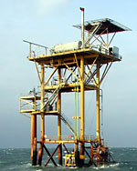
| Owned and maintained by: | Texas Coastal Ocean Observing Network |
| Station Lat, Lon: | 27.76N, 96.98W |
| Buoy type: | Offshore Tower |
| Station elevation: | sea level |
| Anemometer height: | 20 m above site elevation |
|
 |
| A marine forecast is not available for this station. |
| A detailed observation summary is not available for this station. |
| A detailed wave summary is not available for this station. |
| RTOT2 | 27.76N | 96.98W | 100: RTNS Offshore, TX |
| PTAT2 | 27.83N | 97.05W | Port Aransas, TX |
| RTAT2 | 27.84N | 97.07W | 8775237 - Port Aransas, TX |
| NWST2 | 27.75N | 96.77W | 098: NWS Weather Station 1; Gulf of Mexico |
| NGLT2 | 27.82N | 97.20W | 8775283 - Port Ingleside, TX |
| 42048 | 27.94N | 96.84W | TABS D |
| MQTT2 | 27.58N | 97.22W | 8775870 - Malaquite Beach (Corpus Christi), TX |
| MAXT2 | 28.13N | 97.03W | Mission-Aransas Reserve, TX |
| MAQT2 | 28.08N | 97.20W | Mission-Aransas Reserve, TX |
| IRDT2 | 27.48N | 97.32W | 8776139 - South Bird Island, TX |
| BABT2 | 27.30N | 97.42W | 8776604 - Baffin Bay; Point of Rocks, TX |
| SDRT2 | 28.41N | 96.71W | 8773037 - Seadrift, TX |
| 42020 | 26.96N | 96.70W | Corpus Christi, TX 50NM Southeast of Corpus Christi, TX |
| PCNT2 | 28.45N | 96.40W | 8773701 - Matagorda Bay; Port O'Connor, TX |
| 42049 | 28.35N | 96.01W | TABS W |
Data provided by National Data Buoy Center
|
