|
|
| There are no recent reports for this station. |
|
|
|
|
| Owned and maintained by: | National Data Buoy Center |
| Station Lat, Lon: | 31.70N, 79.70W |
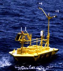
| Buoy type: | 6-meter NOMAD buoy |
| Station elevation: | sea level |
| Air temp height: | 4 m above site elevation |
| Anemometer height: | 5 m above site elevation |
| Barometer elevation: | sea level |
| Sea temp depth: | 1m below site elevation |
|
 |
| A marine forecast is not available for this station. |
| A detailed observation summary is not available for this station. |
| A detailed wave summary is not available for this station. |
| 41005 | 31.70N | 79.70W | |
| TYBG1 | 31.63N | 79.92W | U.S. Navy Tower R8 GA |
| SKMG1 | 31.53N | 80.24W | U.S. Navy Tower M2R6 GA |
| SPAG1 | 31.38N | 80.57W | U.S. Navy Tower R2 GA |
| FRPS1 | 32.28N | 80.41W | 8668498 - Fripps Inlet, SC |
| 41033 | 32.28N | 80.41W | Fripp Nearshore (FRP 2) |
| SVLS1 | 31.95N | 80.68W | Savannah Light, GA |
| 41030 | 32.52N | 79.34W | Capers Mid-Shelf (CAP 3) |
| 41004 | 32.50N | 79.09W | EDISTO - 41 NM Southeast of Charleston, SC |
| FBPS1 | 32.65N | 79.94W | Folly Beach Pier, SC |
| FBIS1 | 32.68N | 79.89W | Folly Island, SC |
| 41021 | 31.92N | 80.85W | Olympic Northeast |
| 41022 | 31.89N | 80.86W | Olympic Southwest |
| 41008 | 31.40N | 80.87W | GRAYS REEF - 40 NM Southeast of Savannah, GA |
| SECG1 | 30.80N | 80.32W | U.S. Navy Tower R4 GA |
Data provided by National Data Buoy Center
|
